We previously mentioned the pilot study on urban growth modeling in Tangier and Marrakech, conducted jointly by Stratec and Vito. We are now completing the second phase of this exciting study, which is of significant interest to the Moroccan Ministry of Territorial Planning and the urban agencies of the Tangier and Marrakech regions but also to our two firms. It is time to look back at the stages of this highly informative study.
The Urban Growth Model: What is it?
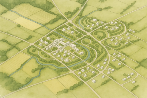
A model was developed to transition from an older observed situation (2000 or 2004) to a second, ‘current’ observed situation (2015 or 2017). A land-use map, featuring about twenty types of occupation (forest, agricultural zone, dense residential area, etc.), was constructed using existing plans and photo-interpretations. Subsequently, the ‘transition rules’ from one type of occupation to another were calibrated. The model integrated the evolutionary logics observed in the past and applies them to predict future situations.
© Vito – Stratec
How Was a ‘Preferential’ Scenario Reached?
A series of development scenarios was modeled for each territory (e.g., ‘trend-based’, ‘densification’, ‘polycentric’ scenarios, etc.). The results were presented to the authorities along with an analysis of the effects concerning resource preservation, soil artificialisation, urban sprawl, distances to the center, etc. Based on this evaluation, we developed a ‘preferential’ scenario for each territory, aiming for the best possible balance.
What is the Purpose of this Work?
The authorities wished to have a detailed understanding of the territories by 2050 to aid in policy design. The analyses highlighted the importance of implementing specific zoning and underscored certain issues: pressure on agricultural areas, overconsumption of space linked to tourist activities, and issues regarding the attractiveness of satellite cities. The results generated significant interest among various stakeholders. A webinar will be organised in 2021.